Sakul Trail Hualien: 1-Hour Loop with Waterfall, Macaques and Taiwan's Endemic Barbet
A 1-hour loop trail just behind Hualien city — wild Formosan macaques, the endemic Taiwan Barbet, a cool waterfall for foot-soaking, and a quiet indigenous renaming story most tourists miss.
Just behind Hualien city — walking or cycling distance from downtown — there’s a 1-hour loop trail that drops you into the forest, past wild Formosan macaques and the call of Taiwan’s endemic Taiwan Barbet, and ends at a cool 20-metre waterfall where you can actually soak your feet. No drive into Taroko, no three-hour itinerary. If you’ve got a free afternoon in Hualien, this is the trade.It’s called the Sakul Trail. You’ll find it on Google Maps under a few different spellings — Shaguer, Saku, Sakul — but the official name is Sakul.
Why It’s Called “Sakul” — A Small Indigenous Renaming Story
The trail was originally named Tso Tsang Trail during the Japanese colonial era. The Sakizaya — an indigenous Hualien community, officially recognised by Taiwan as its 13th indigenous people in 2007 — asked for it to be renamed Sakul, a word from their own language. So it is.
For a visitor, that’s a small thing to walk past. But the name on the sign is itself evidence of an ongoing indigenous cultural revival. Most tourist trails in Taiwan just carry a Chinese name with a phonetic English spelling; Sakul carries both the Sakizaya pronunciation and the characters Hualien locals have used for decades.
What the Trail Looks Like, How Long It Takes
- Total length: 1,350 m (that’s the full loop, not one way)
- Elevation: 70–170 m
- Without stopping to play in the water or take photos: 40 minutes round
- With splashing around + photos: about 1.5 hours
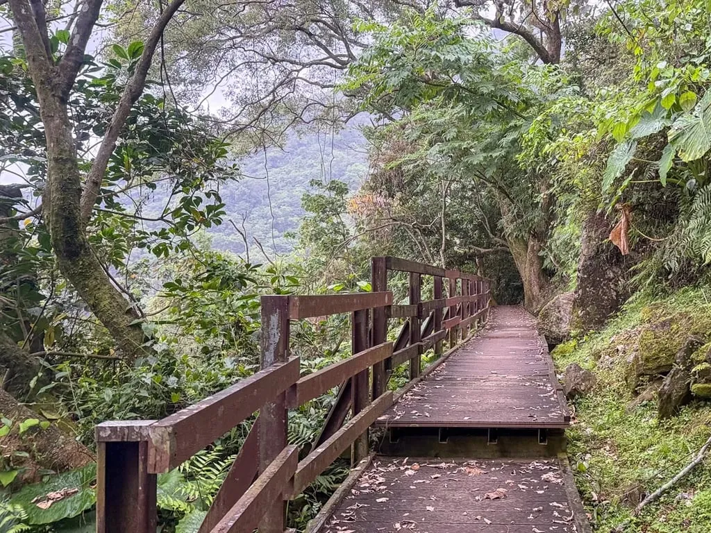
The surface is gravel and natural earth, built with light-touch ecological methods — not a wooden boardwalk the whole way, though the highest section near the observation deck does have one.
Kids do fine here. I regularly bring my 4-year-old up the stone steps and it’s not an issue. The gradient is gentle, but between the stones and loose gravel, wear trainers rather than sandals. The wooden boardwalk gets slippery after rain.
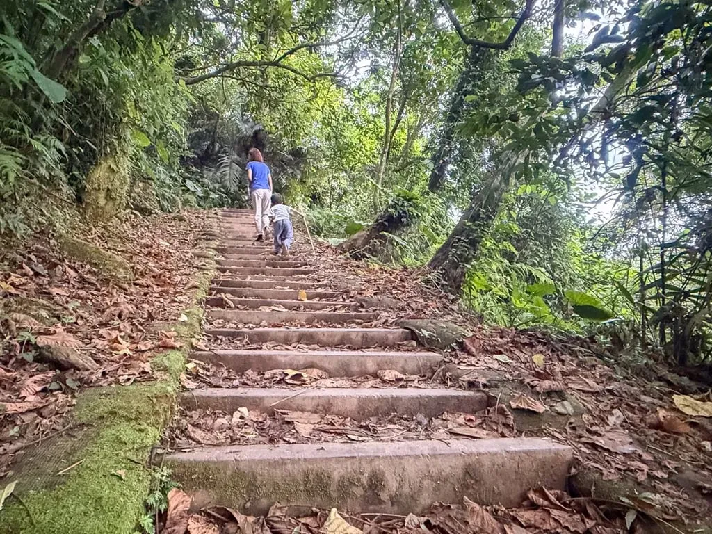
How to Walk the Loop
Just inside the trailhead you’ll hit the first fork — left or right both work, because it’s a loop.
My suggestion: take the right side first. Right-first puts the shaded stretch of trail in front, then the waterfall (foot-soaking, negative-ion stop), and then the gradual climb up to the observation deck — you come down the left side on the way back. The rhythm goes “warm up → climb → coast downhill to the finish”, which is easier on the legs than hitting the steep bit cold. If you don’t want the climb at all, you can also just walk right to the waterfall and come back the way you came.
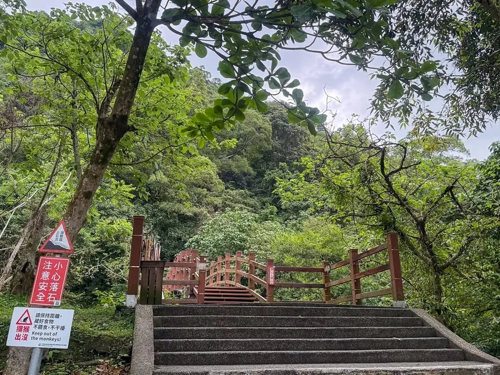
Free Bamboo Hiking Sticks at the Entrance (Return When You’re Done)

There’s a wooden box at the trailhead full of bamboo hiking sticks — free to borrow, please return them when you’re done.
Grab one. The trail itself isn’t steep, but that wooden boardwalk stretch gets slick in the rain, and the sticks genuinely help. On the way down, older walkers and anyone with tricky knees will be glad of them too.
The Waterfall: Foot-Soaking, But Take the Falling Rocks Seriously
About 30 minutes in, you reach the waterfall. Just before the pool there’s a natural rock cave (unworked — a lot of bats live inside). Follow the red safety ring marker and you’re there.
The waterfall itself is around 20 metres high — a thin vertical drop into a shallow pool scattered with rocks of different sizes. Cold in summer: you can kick off your shoes and soak your feet, or — if you’re up for it — stand directly under the water. I do.
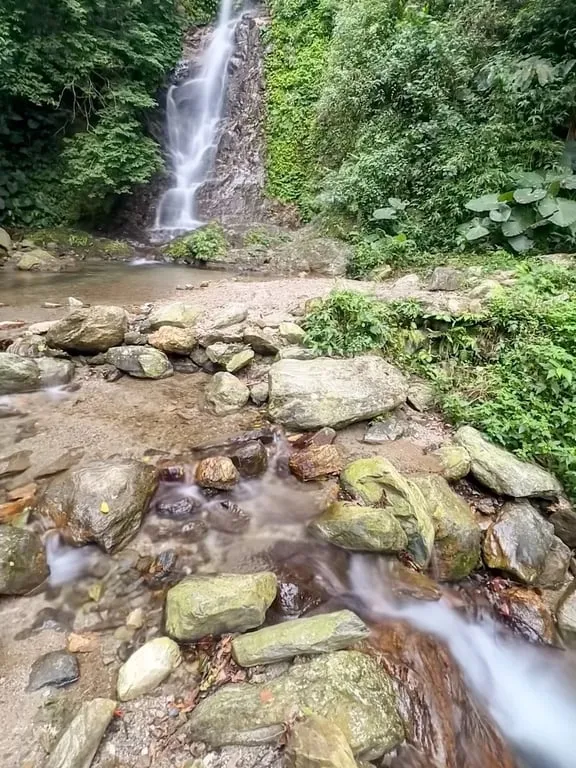
⚠️ This Is an Active Falling-Rock Zone. Read This Bit.
Not a slogan. Playing in the water here is at your own risk. After heavy rain, a typhoon, or recent earthquake activity that could have loosened the slope, just photograph it and move on.
If you don’t want to get wet, you don’t actually need to walk into the waterfall fork at all — continue up and there’s a small platform above the waterfall where you can look down on it. Honestly, the platform itself is nothing special, but it’s breezy up there and you still catch the negative ions.
The Highest Point: Hualien City + the Distant Coast
Keep going up and you hit the wooden observation deck at the top.
From here you get the full Hualien city panorama and, beyond it, the coastline. The big road straight down is Zhongshan Road — Hualien City’s main artery, running all the way to the sea and past both Dongdamen Night Market and Hualien Train Station on the way.
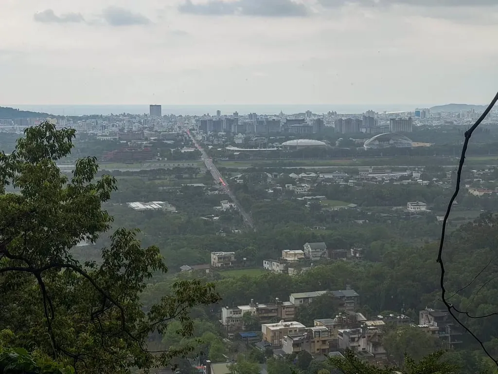
Weather honesty: eastern Taiwan gets regular afternoon rain. The day we went was grey — no blue sea, just a city under mist. On a clear day the view reaches the Pacific. If you’re here for the view specifically, aim for a clear morning — the mist usually thickens later.
Wildlife: Macaques + a Taiwan-Endemic Bird
What makes this trail special isn’t the waterfall — it’s that you can spot genuinely wild animals within walking distance of downtown Hualien.
The Formosan Macaque
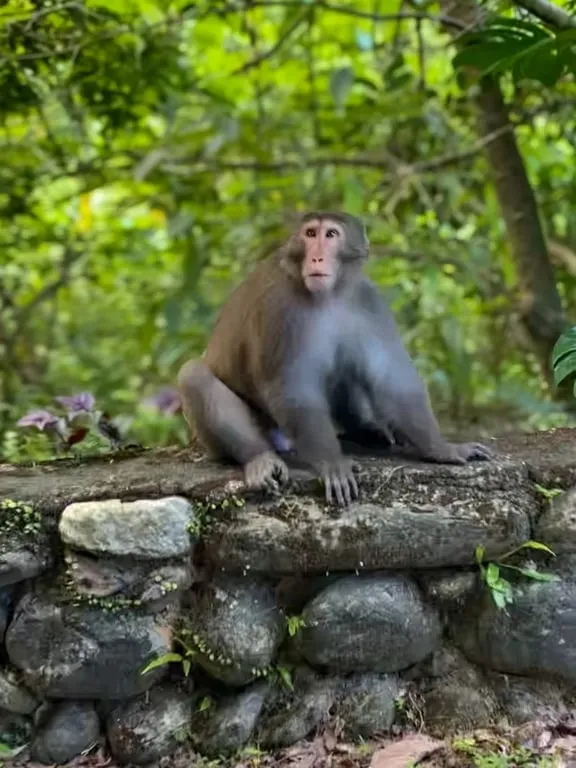
The Formosan macaque is Taiwan’s endemic primate (Macaca cyclopis). They live all over low-altitude Taiwan, and the Sakul population is noticeably dense. How do you know if they’re around? Look up at the treetops — if branches are shaking and something’s moving between them, that’s a monkey overhead.
How to be around Sakul macaques (their behaviour is very different from the monkeys at Japanese hot springs, in Bali, or at Gibraltar — don’t apply those mental models here):
- They do not attack hikers. Walk the trail without worrying; they’ll move out of your way themselves.
- They don’t steal your stuff. As long as you don’t feed them, they have no reason to come close.
- Do not feed them — seriously. Once a troop learns that humans = food, the next hiker down the trail has a problem.
- Don’t step on the droppings. Look where you’re walking.
- Keep distance. Don’t approach suddenly — especially not a baby macaque, because mum is close by.
The Taiwan Barbet

The Taiwan Barbet is a Taiwan endemic (Psilopogon nuchalis). Green body, red throat patch, blue-and-yellow crown — the “five colours” refer to the five shades on its face.
You’ll hear it before you see it. Its call is a distinctive low, rolling “goo-goo-goo-goo-goo” — hit play:
Once you’ve got that sound in your head, you’ll catch one in the canopy before anyone else in your group does. More on the species at Taiwan Barbet on eBird (Cornell Lab’s official bird database).At about 20 cm long, a Barbet is hard to spot against green leaves. If you rent a bike from us, you can add a monocular to your kit — worth it if you’re hoping to see one clearly.
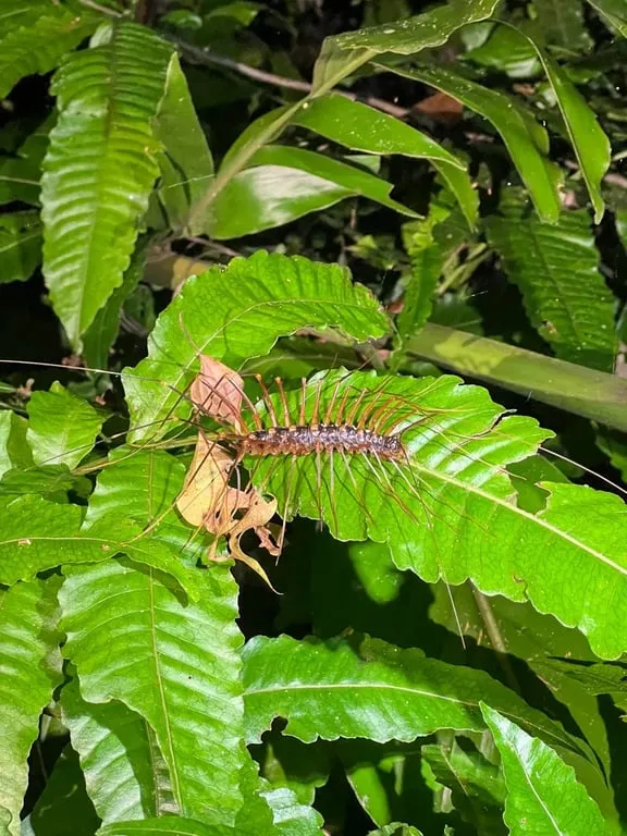
Night Wildlife (Come With a Local Guide)
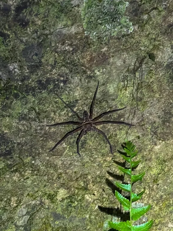
The trail at night is a different world — bats, unusual spiders, various nocturnal small animals. But don’t come alone: it’s dark, the path is slippery, and wildlife at night is less predictable. If you come with us or a local guide you’ll see far more (and occasionally bump into local indigenous hunters).
When to Come
Any season works — the trail is gentle, mostly shaded, mild in winter, pleasant in spring and autumn, and summer is the fun one because the waterfall becomes a cool-off stop.
- Summer (June–August): the water season. Coming up from a muggy Hualien city and soaking your feet under the falls is the specific reason to visit in summer.
- April–May: bonus Tung blossom season. The forest floor gets a layer of white petals that looks a bit like snow.
- October–March: comfortable temperatures, fewer people. Good for walking, wildlife spotting, and the city view.
- Heavy rain / after a typhoon: walk the trail but stay out of the water. Falling-rock risk is real.
- Time of day: Hualien gets afternoon rain often. If you want a clear view from the deck, come in the morning.
How to Get There
Sakul Trail is in the hills right behind downtown Hualien — this isn’t one of those drive-half-an-hour-into-the-park situations. From Hualien Train Station or Dongdamen Night Market, you’re looking at a 15–20 minute cycle to the trailhead.
Two ways there:
- By bike (recommended). Rent one, cycle through flat city streets to the trailhead, and on the way back swing by the night market or the coast. We’ll post a full Hualien cycling-route guide soon.
- With us, by driver. If you’d rather not sort out your own transport and want to string Sakul together with Taroko, the coast, and the night market in one day, that’s what we do — a private driver tour with everything arranged.
Practical Info
- Trail name: Sakul Trail
- Location: On the west side of Hualien City; search “Sakul Trail” on Google Maps
- Managed by: Forestry and Nature Conservation Agency, Hualien Branch
- Length: 1,350 m loop; 70–170 m elevation; about 1 hour round-trip
- Difficulty: Beginner — young children and older walkers both manage
- Cost: Free
- Hours: Open access, no gate
- Facilities: Public toilet near the finish; free bamboo hiking-stick loan at the start
- Bring: Trainers (no sandals), water, mosquito repellent (midges in summer), sunscreen, borrow a stick on site
- Don’t bring: Food you’d feed to animals (don’t feed the macaques)
- Warnings: Falling-rock zone at the waterfall pool; slick boardwalks after rain; keep distance from macaques
Planning your Hualien trip and want local knowledge on short trails and wildlife spotting? Ping us on WhatsApp — we reply in English:
Chat with us on WhatsApp